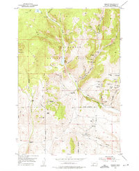
1952 Map of Ermont
USGS Topo · Published 1975About this map
Mining operations and high-altitude ranching dominate this 1952 study of the Beaverhead County backcountry. The landscape is defined by the Pioneer Mountains and a dense concentration of mineral claims along the eastern slopes, where the Yellow Band Mine, Argenta Mine, and Rena Mine mark a significant silver and lead district. The presence of the Ermont Mill and the Ermont Diversion Dam near the southern boundary highlights the industrial infrastructure required to process ore in this remote terrain.
Find a feature on this map
61 named features on this map. Tap any name to fly to it.
Don’t see what you’re looking for? This feature index may not catch every label — zoom into the map to look around manually.
Map Details
Editions of this 1952 Ermont Map
5 editions found
Other maps of this area

1893 · Dillon
USGS Topo · 1:250,000

1952 · Twin Adams Mountain
USGS Topo · 1:24,000

1952 · Argenta
USGS Topo · 1:24,000

1952 · Bannack
USGS Topo · 1:24,000

1952 · Burns Mountain
USGS Topo · 1:24,000

1952 · Torrey Mountain
USGS Topo · 1:24,000

1952 · Ermont
USGS Topo · 1:24,000

1955 · Dillon
USGS Topo · 1:250,000

1957 · Dillon
USGS Topo · 1:250,000

1958 · Dillon
USGS Topo · 1:250,000