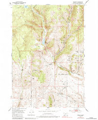
1952 Map of Ermont
USGS Topo · Published 1984About this map
The Pioneer Mountains define the high country of this mid-century survey, where the rugged terrain of the Beaverhead National Forest is deeply scarred by a century of hard-rock mining. The southeastern corner of the map reveals a concentrated industrial landscape centered around Ermont Mill and several nearby extractions like the Ermont No 2 Mine and Badger Mine. These operations were served by the Ermont Road, which follows the natural corridor of Rattlesnake Creek as it winds toward the valley. Further north, the map documents a transition from mining to ranching, with the Pilon Ranch and Carroll Ranch occupying the lower slopes. A notable historical relic, the Coke Kiln near Little Bear Gulch, suggests the early presence of smelting operations used to process ores from the surrounding claims.
Find a feature on this map
55 named features on this map. Tap any name to fly to it.
Don’t see what you’re looking for? This feature index may not catch every label — zoom into the map to look around manually.
Map Details
Editions of this 1952 Ermont Map
5 editions found
Other maps of this area

1893 · Dillon
USGS Topo · 1:250,000

1952 · Twin Adams Mountain
USGS Topo · 1:24,000

1952 · Argenta
USGS Topo · 1:24,000

1952 · Bannack
USGS Topo · 1:24,000

1952 · Burns Mountain
USGS Topo · 1:24,000

1952 · Torrey Mountain
USGS Topo · 1:24,000

1952 · Ermont
USGS Topo · 1:24,000

1955 · Dillon
USGS Topo · 1:250,000

1957 · Dillon
USGS Topo · 1:250,000

1958 · Dillon
USGS Topo · 1:250,000