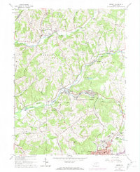
1963 Map of Ernest
USGS Topo · Published 1974About this map
The industrial and rural landscape north of Indiana is defined by the winding course of Crooked Creek and the operations of the Baltimore and Ohio railroad. In the early 1960s, the area around the company town of Ernest and nearby Creekside shows the physical footprint of the region's coal heritage, with several mine dumps and air shafts dotting the hillsides. The map captures a transition from dense residential clusters like Chevy Chase Heights to the scattered farming communities of Atwood and Five Points.
Find a feature on this map
65 named features on this map. Tap any name to fly to it.
Don’t see what you’re looking for? This feature index may not catch every label — zoom into the map to look around manually.
Map Details
Editions of this 1963 Ernest Map
4 editions found
Other maps of this area

1901 · Rural Valley
USGS Topo · 1:62,500

1902 · Indiana
USGS Topo · 1:62,500

1902 · Elders Ridge
USGS Topo · 1:62,500

1903 · Rural Valley
USGS Topo · 1:62,500

1904 · Elders Ridge
USGS Topo · 1:62,500

1909 · Smicksburg
USGS Topo · 1:62,500

1938 · Smicksburg
USGS Topo · 1:62,500

1939 · Smicksburg
USGS Topo · 1:62,500

1953 · Pittsburgh
USGS Topo · 1:250,000

1954 · Pittsburgh
USGS Topo · 1:250,000