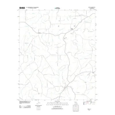
2012 Map of Eros
USGS Topo · Published 2012About this map
Eros serves as a central hub for this corner of Jackson Parish, where a network of local roads connects the community to outlying settlements like Cartwright, Guyton, and Indian Village. The landscape is heavily defined by its drainage systems, including the wandering paths of S Choudrant Cr and Flat Cr. The area’s economic activity is evidenced by the presence of energy infrastructure, specifically the Cartwright Gas Field and Eros Gas Field. For those researching local family history, the map preserves the locations of numerous small burial grounds, such as Butler Cem, Old Zeigler Cem, and Indian Village Cem. This survey illustrates a quiet, rural Louisiana parish characterized by family-named landmarks and the persistent flow of creeks like N Cheniere Cr through the piney woods of the early 21st century.
Find a feature on this map
103 named features on this map. Tap any name to fly to it.
Don’t see what you’re looking for? This feature index may not catch every label — zoom into the map to look around manually.
Map Details
Editions of this 2012 Eros Map
This is the sole edition of this map. No revisions or reprints were ever made.
Other maps of this area

1950 · Ruston
USGS Topo · 1:62,500

1951 · Ruston
USGS Topo · 1:62,500

1952 · Calhoun
USGS Topo · 1:62,500

1953 · Chatham
USGS Topo · 1:62,500

1953 · Hodge
USGS Topo · 1:62,500

1955 · Shreveport
USGS Topo · 1:250,000

1956 · Shreveport
USGS Topo · 1:250,000

1982 · Chatham
USGS Topo · 1:24,000
1982 · Calhoun
USGS Topo · 1:24,000

1982 · Chatham SE
USGS Topo · 1:24,000