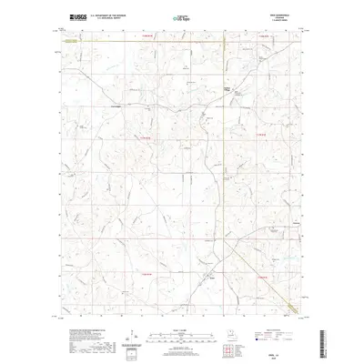
2020 Map of Eros
USGS Topo · Published 2020About this map
The town of Eros serves as the focal point for this 2020 study of northern Louisiana, situated at the crossroads where Jackson Parish meet Lincoln Parish and Ouachita Parish. The landscape is defined by its numerous small burial grounds and rural settlements, illustrating the deep genealogical roots of the region. Distinctive features like the Indian Village Cem and Cartwright Cem are scattered among the timbered terrain and small creek drainages such as S Choudrant Cr and Flat Cr. Settlement patterns follow the local road network, including Parish Rd 238 and 144, which connect smaller communities like Cartwright and Indian Village to the larger surrounding area. The map reveals a high density of named family cemeteries, such as the Wright Family Cem and Old Zeigler Cem, which provide essential landmarks for researchers tracing the historical occupancy of this corner of the state.
Find a feature on this map
107 named features on this map. Tap any name to fly to it.
Don’t see what you’re looking for? This feature index may not catch every label — zoom into the map to look around manually.
Map Details
Editions of this 2020 Eros Map
This is the sole edition of this map. No revisions or reprints were ever made.
Other maps of this area

1950 · Ruston
USGS Topo · 1:62,500

1951 · Ruston
USGS Topo · 1:62,500

1952 · Calhoun
USGS Topo · 1:62,500

1953 · Chatham
USGS Topo · 1:62,500

1953 · Hodge
USGS Topo · 1:62,500

1955 · Shreveport
USGS Topo · 1:250,000

1956 · Shreveport
USGS Topo · 1:250,000

1982 · Chatham
USGS Topo · 1:24,000
1982 · Calhoun
USGS Topo · 1:24,000

1982 · Chatham SE
USGS Topo · 1:24,000