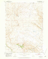
1952 Map of Ervay Basin
USGS Topo · Published 1965About this map
Ervay Basin defines the central landscape of this mid-century survey, revealing a remote ranching and grazing district in central Wyoming. The settlement of Raderville stands as a focal point in the eastern portion, situated near the headwaters of the Powder River. The map documents a sparse human footprint centered around the JE Ranch and the nearby JE School, which likely served the families of the local basin during the early 1950s. The terrain is marked by significant topographical landmarks such as Maverick Butte and Cyclone Ridge, with essential water resources like Sulphur Spring and Defelder Reservoir noted. Industrial activity is represented by a small Quarry and a traversing Pipe Line, while the winding Poison Spider Rd provides primary access through the broken terrain of the Coalbank Hills.
Find a feature on this map
23 named features on this map. Tap any name to fly to it.
Don’t see what you’re looking for? This feature index may not catch every label — zoom into the map to look around manually.
Map Details
Editions of this 1952 Ervay Basin Map
3 editions found
Other maps of this area

1952 · Ervay Basin SW
USGS Topo · 1:24,000

1952 · Arminto SW
USGS Topo · 1:24,000

1952 · Gas Hills
USGS Topo · 1:24,000

1952 · Moneta SE
USGS Topo · 1:24,000

1952 · Miles Ranch
USGS Topo · 1:24,000

1952 · Hiland
USGS Topo · 1:24,000

1952 · Ervay Basin
USGS Topo · 1:24,000

1955 · Arminto
USGS Topo · 1:250,000

1955 · Casper
USGS Topo · 1:250,000

1957 · Miles Ranch
USGS Topo · 1:24,000