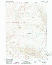
1952 Map of Ervay Basin
USGS Topo · Published 1986About this map
The high desert landscape of central Wyoming is documented here through a focus on the Ervay Basin, a region defined by scattered springs and significant topographic relief. Ranching and early aviation infrastructure characterize the settlement pattern, as seen with the JE Ranch, the adjacent JE School, and a remote Landing Strip to the southwest. The presence of JE Sulphur Spring and Collins Spring highlights the critical importance of water sources in this arid terrain, while the Pipeline crossing the eastern sections indicates the industrial development that arrived alongside traditional land uses.
Find a feature on this map
21 named features on this map. Tap any name to fly to it.
Don’t see what you’re looking for? This feature index may not catch every label — zoom into the map to look around manually.
Map Details
Editions of this 1952 Ervay Basin Map
3 editions found
Other maps of this area

1952 · Ervay Basin SW
USGS Topo · 1:24,000

1952 · Arminto SW
USGS Topo · 1:24,000

1952 · Gas Hills
USGS Topo · 1:24,000

1952 · Moneta SE
USGS Topo · 1:24,000

1952 · Miles Ranch
USGS Topo · 1:24,000

1952 · Hiland
USGS Topo · 1:24,000

1952 · Ervay Basin
USGS Topo · 1:24,000

1955 · Arminto
USGS Topo · 1:250,000

1955 · Casper
USGS Topo · 1:250,000

1957 · Miles Ranch
USGS Topo · 1:24,000