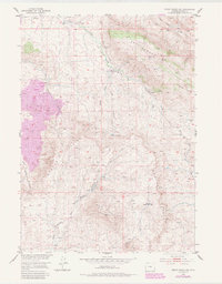
1984 Map of Ervay Basin SW
USGS Topo · Published 1985About this map
Rattlesnake Hills and the prominent Beaver Rim define this high-altitude landscape in central Wyoming, where historical settlement is marked by isolated sites like the Holiday Homestead (Aband) and the Aspell Homestead Site. The terrain is a network of drainage systems including Deer Creek, Little Cross Creek, and the headwaters of the Middle Fork Sage Creek, which flows south from Black Mountain.
Find a feature on this map
20 named features on this map. Tap any name to fly to it.
Don’t see what you’re looking for? This feature index may not catch every label — zoom into the map to look around manually.
Map Details
Editions of this 1984 Ervay Basin SW Map
This is the sole edition of this map. No revisions or reprints were ever made.
Other maps of this area

1952 · Ervay Basin SW
USGS Topo · 1:24,000

1952 · Gas Hills
USGS Topo · 1:24,000

1952 · Miles Ranch
USGS Topo · 1:24,000

1952 · Ervay Basin
USGS Topo · 1:24,000

1952 · Mc Intosh Meadows
USGS Topo · 1:24,000

1955 · Casper
USGS Topo · 1:250,000

1957 · Miles Ranch
USGS Topo · 1:24,000

1958 · Casper
USGS Topo · 1:250,000
1958 · Gas Hills
USGS Topo · 1:24,000
1959 · Mc Rae Gap
USGS Topo · 1:24,000