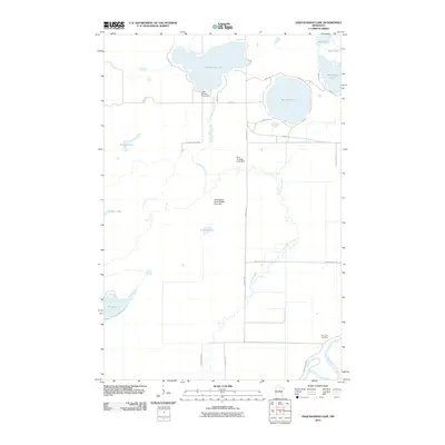
2010 Map of Esquagamah Lake
USGS Topo · Published 2010About this map
Esquagamah Lake and Round Lake anchor a landscape defined by glacial waters and conservation management in this 2010 Aitkin County survey. The Little Willow River meanders southward through the central quadrangle, its flow controlled by structures such as the Little Willow River Dam and the Little Willow River Wildlife Area Dam. These features, alongside the Little Willow WMA, highlight the region's importance for wildlife habitat and water regulation. In the southeast corner, the Mississippi River cuts a wide path, followed closely by the Great River Rd. This area also contains the Riverside Cemetery, a key landmark for local genealogical research located near the river's bend. The map illustrates a transition from the dense lake clusters of Waukenabo Lake and East Lake in the northeast to the more isolated basins of Lizer Lake and Blind Lake in the southwest, connected by a network of rural township roads.
Find a feature on this map
30 named features on this map. Tap any name to fly to it.
Don’t see what you’re looking for? This feature index may not catch every label — zoom into the map to look around manually.
Map Details
Editions of this 2010 Esquagamah Lake Map
This is the sole edition of this map. No revisions or reprints were ever made.
Other maps of this area

1913 · Cuyuna
USGS Topo · 1:62,500

1914 · Aitkin
USGS Topo · 1:62,500

1915 · Aitkin
USGS Topo · 1:62,500

1915 · Cuyuna
USGS Topo · 1:62,500

1953 · Duluth
USGS Topo · 1:250,000

1958 · Duluth
USGS Topo · 1:250,000

1970 · Edna Lake
USGS Topo · 1:24,000

1970 · Bain
USGS Topo · 1:24,000

1970 · White Elk Lake
USGS Topo · 1:24,000

1973 · Iron Hub
USGS Topo · 1:24,000