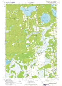
1973 Map of Esquagamah Lake
USGS Topo · Published 1975About this map
Esquagamah Lake and its surrounding wetlands define this Aitkin County landscape, where glacial waters collected into a dense network of basins and slow-moving rivers during the early 1970s. The northern portion of the map is dominated by large water bodies like Round Lake and Waukenabo Lake, while the central section preserves the natural character of the Little Willow State Wildlife Management Area. This territory represents a classic Minnesota transition from open water to marshland, eventually feeding south into the Mississippi River near the Riverside Cem. Aside from the small Hill Top Chapel, the map reflects a region primarily shaped by nature and conservation rather than dense settlement, with scattered Gravel Pits indicating local resource extraction amid the timber and waterways.
Find a feature on this map
18 named features on this map. Tap any name to fly to it.
Don’t see what you’re looking for? This feature index may not catch every label — zoom into the map to look around manually.
Map Details
Editions of this 1973 Esquagamah Lake Map
This is the sole edition of this map. No revisions or reprints were ever made.
Other maps of this area

1913 · Cuyuna
USGS Topo · 1:62,500

1914 · Aitkin
USGS Topo · 1:62,500

1915 · Aitkin
USGS Topo · 1:62,500

1915 · Cuyuna
USGS Topo · 1:62,500

1953 · Duluth
USGS Topo · 1:250,000

1958 · Duluth
USGS Topo · 1:250,000

1970 · Edna Lake
USGS Topo · 1:24,000

1970 · Bain
USGS Topo · 1:24,000

1970 · White Elk Lake
USGS Topo · 1:24,000

1973 · Iron Hub
USGS Topo · 1:24,000