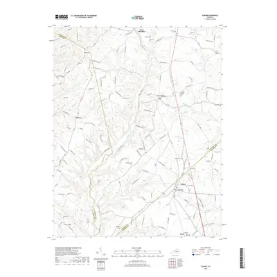
2019 Map of Eubank
USGS Topo · Published 2019About this map
Eubank serves as a primary hub for this corridor along the Norfolk Southern railway, situated where the borders of Lincoln, Casey, and Pulaski Counties converge. The landscape is defined by the headwaters of Fishing Creek and the dissected terrain of Ellison Ridge and Polly Ann Ridge. This 2019 survey documents a landscape heavily dotted with family and church cemeteries, such as Double Spring Cem and Falconbury Cem, which indicate long-standing patterns of rural settlement and genealogy. Rural infrastructure is centered around crossroads like Duncan, Waynesburg, and Walltown, where legacy institutions like the Pond School and Friendship Church remain established. The topography transitions from the higher elevations near Kings Knob down into the narrow valleys of Buffalo Hollow and Rocky Hollow, showing the intricate drainage network that feeds into the larger Cumberland River system further south.
Find a feature on this map
127 named features on this map. Tap any name to fly to it.
Don’t see what you’re looking for? This feature index may not catch every label — zoom into the map to look around manually.
Map Details
Editions of this 2019 Eubank Map
This is the sole edition of this map. No revisions or reprints were ever made.
Other maps of this area

1935 · Somerset
USGS Topo · 1:62,500

1952 · Halls Gap
USGS Topo · 1:24,000

1952 · Eubank
USGS Topo · 1:24,000

1952 · Crab Orchard
USGS Topo · 1:24,000

1952 · Hustonville
USGS Topo · 1:24,000

1952 · Yosemite
USGS Topo · 1:24,000

1952 · Woodstock
USGS Topo · 1:24,000

1953 · Mintonville
USGS Topo · 1:24,000
1954 · Bobtown
USGS Topo · 1:24,000

1954 · Science Hill
USGS Topo · 1:24,000