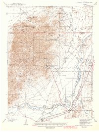
1942 Map of Eugene Mountains Area
USGS Topo · Published 1942About this map
The Nevada-Massachusetts Tungsten Mine dominates the southeastern slopes of the Eugene Mountains in this 1939 survey, reflecting the region's industrial importance during the pre-war era. This mining complex is connected to the valley floor by a dedicated Water Pipe Line, illustrating the intensive infrastructure required for high-desert mineral extraction. The map documents the vital transport corridor along the Humboldt River, where the Southern Pacific and Western Pacific railroads parallel the historic Emigrant Trail and the modernized Victory Highway. Local life is anchored by small settlements like Imlay and Mill City, while remote outposts such as Thackers Ranch and Millers Cabin appear as lonely landmarks in the surrounding basins and canyons. Notable geological features like Alpha Butte and Pole Canyon provide a sharp vertical contrast to the river bottomlands near Callahan Bridge.
Find a feature on this map
35 named features on this map. Tap any name to fly to it.
Don’t see what you’re looking for? This feature index may not catch every label — zoom into the map to look around manually.
Map Details
Editions of this 1942 Eugene Mountains Area Map
2 editions found
Other maps of this area

1931 · Lovelock
USGS Topo · 1:250,000

1932 · Sonoma Range
USGS Topo · 1:250,000

1935 · Lovelock
USGS Topo · 1:250,000

1939 · Sonoma Range
USGS Topo · 1:250,000

1939 · Eugene Mountains Area
USGS Topo · 1:62,500

1942 · Eugene Mountains Area
USGS Topo · 1:62,500

1955 · Lovelock
USGS Topo · 1:250,000

1955 · Winnemucca
USGS Topo · 1:250,000

1956 · Imlay
USGS Topo · 1:62,500

1958 · Winnemucca
USGS Topo · 1:250,000