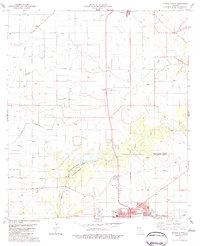
1983 Map of Eunice North
USGS Topo · Published 1983About this map
Eunice and the surrounding prairie of south-central Louisiana are defined by a complex network of bayous and agricultural development. The boundary between Evangeline Parish and St Landry Parish cuts across a landscape dominated by the Missouri Pacific railroad line, which anchors the city's southern edge. Numerous small family cemeteries like Rougeau Cem, Fontenot Cem, and Ashford Cem are scattered across the rural sections, offering significant data for genealogical research in this Acadiana region.
Find a feature on this map
33 named features on this map. Tap any name to fly to it.
Don’t see what you’re looking for? This feature index may not catch every label — zoom into the map to look around manually.
Map Details
Editions of this 1983 Eunice North Map
This is the sole edition of this map. No revisions or reprints were ever made.
Other maps of this area

1947 · Ville Platte
USGS Topo · 1:31,680

1947 · Fruge Lake
USGS Topo · 1:31,680

1947 · Redland
USGS Topo · 1:31,680

1947 · Chataignier
USGS Topo · 1:31,680

1947 · Bond
USGS Topo · 1:31,680

1947 · Eunice
USGS Topo · 1:31,680

1947 · Pitreville
USGS Topo · 1:31,680

1947 · Basile
USGS Topo · 1:31,680

1949 · Basile
USGS Topo · 1:31,680

1952 · Lake Charles
USGS Topo · 1:250,000