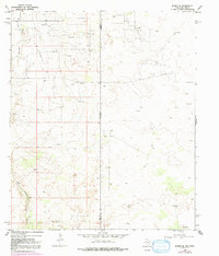
1969 Map of Eunice SE
USGS Topo · Published 1991About this map
Paddock South Oil Field and the surrounding energy landscape dominate this arid stretch of the Permian Basin during the late 1960s. The map illustrates a complex network of industrial activity straddling the New Mexico Texas boundary, where the heavy presence of an Oil Well, numerous Drill Hole sites, and scattered Gravel Pit operations reveal the intensity of postwar petroleum extraction. The terrain is marked by the meandering path of Monument Draw, which cuts through the sandy topography of Lea and Andrews Counties.
Find a feature on this map
14 named features on this map. Tap any name to fly to it.
Don’t see what you’re looking for? This feature index may not catch every label — zoom into the map to look around manually.
Map Details
Editions of this 1969 Eunice SE Map
Other maps of this area

1954 · Hobbs
USGS Topo · 1:250,000

1958 · Hobbs
USGS Topo · 1:250,000

1969 · Jal NE
USGS Topo · 1:24,000

1969 · Eunice
USGS Topo · 1:24,000

1969 · Eunice NE
USGS Topo · 1:24,000

1969 · Eunice SE
USGS Topo · 1:24,000

1969 · Jal NW
USGS Topo · 1:24,000

1969 · Rattlesnake Canyon
USGS Topo · 1:24,000

1971 · Jumbo Hill
USGS Topo · 1:24,000

1971 · Figure Seven Ranch
USGS Topo · 1:24,000