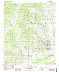
1983 Map of Eupora
USGS Topo · Published 1984About this map
Eupora and Walthall anchor this rural Webster County landscape in the early 1980s, revealing a region defined by its numerous small-scale communities and religious centers. The Columbus and Greenville railroad corridor follows the southern edge of Eupora, while a dense network of country churches like South Union Ch, Lebanon Ch, and Soul City House of God serve the surrounding countryside. Topographically, the area is characterized by low-lying drainages including Little Sand Creek and Whites Creek, alongside modest elevations such as Sand Mountain and Rocky Mountain. Genealogists will find particular value in the documentation of several family and community burial grounds, including Old Greensboro Cem, Hays Cem, and Cooper Cem. The presence of the Eupora Airport and the Scogin Landing Strip indicates the region's mid-century aviation infrastructure in this quiet corner of Mississippi.
Find a feature on this map
48 named features on this map. Tap any name to fly to it.
Don’t see what you’re looking for? This feature index may not catch every label — zoom into the map to look around manually.
Map Details
Editions of this 1983 Eupora Map
2 editions found
Other maps of this area

1953 · Walthall
USGS Topo · 1:62,500

1953 · West Point
USGS Topo · 1:250,000

1958 · West Point
USGS Topo · 1:250,000

1963 · West Point
USGS Topo · 1:250,000

1966 · Stewart
USGS Topo · 1:24,000

1966 · Tomnolen
USGS Topo · 1:24,000

1968 · Weir
USGS Topo · 1:62,500

1972 · Sapa
USGS Topo · 1:24,000

1972 · Hohenlinden
USGS Topo · 1:24,000
1972 · Reform
USGS Topo · 1:24,000