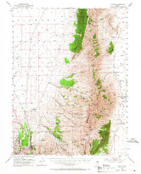
1953 Map of Eureka
USGS Topo · Published 1966About this map
The town of Eureka serves as the focal point for this 1953 survey, situated at the southern end of the massive Diamond Mountains. The landscape is a study in the transition from active mining and transport to ranching, with the Eureka Nevada Railroad and the famed Lincoln Highway providing vital connections across the high desert. Mining remains a visible legacy through features like the Phillipsburg Mine, Smelter Ruins, and the Smelter Stack, while the surrounding slopes are dotted with family enterprises such as Strawberry Ranch, De Bernardi Ranch, and Hunters Ranch (Old Shipley Station). Education and community life are marked by the Newark Valley School, positioned east of the rugged peaks. The towering Diamond Peak and Alpha Peak dominate the skyline, overlooking the broad expanse of Diamond Valley.
Find a feature on this map
65 named features on this map. Tap any name to fly to it.
Don’t see what you’re looking for? This feature index may not catch every label — zoom into the map to look around manually.
Map Details
Editions of this 1953 Eureka Map
3 editions found
Other maps of this area

1926 · Roberts Mountains
USGS Topo · 1:250,000

1929 · Roberts Mountains
USGS Topo · 1:250,000

1949 · Garden Valley
USGS Topo · 1:62,500

1951 · Garden Valley
USGS Topo · 1:62,500

1951 · Pancake Summit
USGS Topo · 1:62,500

1953 · Pinto Summit
USGS Topo · 1:62,500

1953 · Eureka
USGS Topo · 1:62,500

1955 · Millett
USGS Topo · 1:250,000

1956 · Bellevue Peak
USGS Topo · 1:62,500

1956 · Whistler Mtn
USGS Topo · 1:62,500