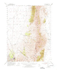
1953 Map of Eureka
USGS Topo · Published 1975About this map
Eureka serves as the industrial and social anchor of this mid-century survey, surrounded by a dense network of silver and lead mining operations. The southern portion of the map is particularly rich in mining history, detailing specific shafts such as the Richmond Shaft and Ruby Hill, alongside legacy structures like Smelter Ruins and a Charcoal Kiln. Beyond the town, the landscape transitions into the high peaks of the Diamond Mountains, where Diamond Peak towers over a rugged expanse of canyons and springs. High-altitude mining activity continues at the Bay State Mine near Newark Mtn, illustrating the extent of mineral extraction in the region. Agricultural life is evidenced by numerous family-named holdings, including Eunice Place and the Hunters Ranch, while an Old Railroad Grade and the Lincoln Highway trace the evolution of Great Basin transportation through the Diamond Valley.
Find a feature on this map
74 named features on this map. Tap any name to fly to it.
Don’t see what you’re looking for? This feature index may not catch every label — zoom into the map to look around manually.
Map Details
Editions of this 1953 Eureka Map
3 editions found
Other maps of this area

1926 · Roberts Mountains
USGS Topo · 1:250,000

1929 · Roberts Mountains
USGS Topo · 1:250,000

1949 · Garden Valley
USGS Topo · 1:62,500

1951 · Garden Valley
USGS Topo · 1:62,500

1951 · Pancake Summit
USGS Topo · 1:62,500

1953 · Pinto Summit
USGS Topo · 1:62,500

1953 · Eureka
USGS Topo · 1:62,500

1955 · Millett
USGS Topo · 1:250,000

1956 · Bellevue Peak
USGS Topo · 1:62,500

1956 · Whistler Mtn
USGS Topo · 1:62,500