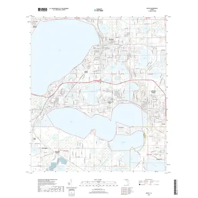
2018 Map of Eustis
USGS Topo · Published 2018About this map
Lake County's intricate chain of lakes dominates this 2018 survey, centered on the historic citrus and residential centers of Eustis, Mount Dora, and Tavares. The landscape is defined by the expansive waters of Lake Eustis and Lake Dora, which shaped the early development of these towns. Within the urban grid of Eustis, significant local history sites such as Greenwood Cem and the residential area of Mount Homer are documented. The transition between the towns includes smaller water bodies like Lake Joanna and Lake Gertrude, reflecting the density of inland waterways that characterize this part of Florida.
Find a feature on this map
222 named features on this map. Tap any name to fly to it.
Don’t see what you’re looking for? This feature index may not catch every label — zoom into the map to look around manually.
Map Details
Editions of this 2018 Eustis Map
This is the sole edition of this map. No revisions or reprints were ever made.
Other maps of this area

1955 · Orlando
USGS Topo · 1:250,000

1957 · Orlando
USGS Topo · 1:250,000

1958 · Orlando
USGS Topo · 1:250,000

1960 · Sorrento
USGS Topo · 1:24,000

1960 · Apopka
USGS Topo · 1:24,000

1962 · Orlando
USGS Topo · 1:250,000

1962 · Astatula
USGS Topo · 1:24,000

1965 · Leesburg East
USGS Topo · 1:24,000

1965 · Umatilla
USGS Topo · 1:24,000
1965 · Paisley
USGS Topo · 1:24,000