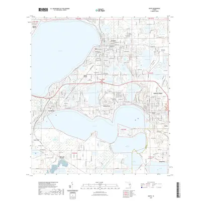
2021 Map of Eustis
USGS Topo · Published 2021About this map
Eustis, Tavares, and Mount Dora anchor this high-resolution topographical study of central Florida's lake-rich landscape. The area is defined by an intricate network of interconnected basins, including the massive Lake Eustis, Lake Dora, and Lake Beauclair, which historically facilitated the region's transport and settlement patterns. Genealogists and local historians will find significant detail in the mapping of numerous burial grounds and memorial sites, such as Greenwood Cem in Eustis and Pine Forest Cem in Mount Dora. The map also records the institutional heart of the county at the Lake County Courthouse. To the south, smaller communities like Ellsworth Junction and Tangerine are documented along with specialized infrastructure like the Mid Florida Air Service airfield and the Southern Technical College Mount Dora Campus, reflecting the area's modern development around its traditional water-centric geography.
Find a feature on this map
73 named features on this map. Tap any name to fly to it.
Don’t see what you’re looking for? This feature index may not catch every label — zoom into the map to look around manually.
Map Details
Editions of this 2021 Eustis Map
This is the sole edition of this map. No revisions or reprints were ever made.
Other maps of this area

1955 · Orlando
USGS Topo · 1:250,000

1957 · Orlando
USGS Topo · 1:250,000

1958 · Orlando
USGS Topo · 1:250,000

1960 · Sorrento
USGS Topo · 1:24,000

1960 · Apopka
USGS Topo · 1:24,000

1962 · Orlando
USGS Topo · 1:250,000

1962 · Astatula
USGS Topo · 1:24,000

1965 · Leesburg East
USGS Topo · 1:24,000

1965 · Umatilla
USGS Topo · 1:24,000
1965 · Paisley
USGS Topo · 1:24,000