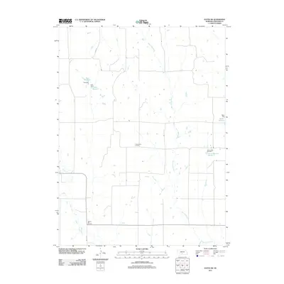
2011 Map of Eustis SW
USGS Topo · Published 2011About this map
West Muddy Creek defines the drainage of this portion of Frontier County, cutting a meandering path through a landscape largely shaped by agricultural water management. The terrain is marked by a series of localized water projects, including the Hess Reservoir and Klein Reservoir in the northwest, and the Schurr Reservoir Number 2 and Berke Reservoir to the east. These man-made features, supported by structures like Hess Dam and Berke Dam, reflect the essential role of irrigation and livestock water in the Nebraska plains. For those tracing local history or family roots, the map provides precise locations for the Independence Cemetery and Pleasant Hill Cemetery, which stand as significant markers of the area's rural communities and early settlers in this quiet section of the state.
Find a feature on this map
15 named features on this map. Tap any name to fly to it.
Don’t see what you’re looking for? This feature index may not catch every label — zoom into the map to look around manually.
Map Details
Editions of this 2011 Eustis SW Map
This is the sole edition of this map. No revisions or reprints were ever made.
Other maps of this area

1902 · Gothenburg
USGS Topo · 1:125,000

1954 · McCook
USGS Topo · 1:250,000

1956 · Freedom
USGS Topo · 1:24,000

1956 · Stockville NE
USGS Topo · 1:24,000

1956 · Medicine Creek Dam
USGS Topo · 1:24,000

1956 · Stockville SE
USGS Topo · 1:24,000

1957 · McCook
USGS Topo · 1:250,000

1958 · McCook
USGS Topo · 1:250,000
1970 · Eustis SW
USGS Topo · 1:24,000
1970 · Eustis
USGS Topo · 1:24,000