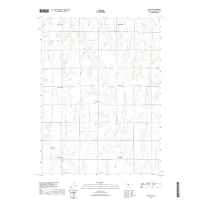
2017 Map of Eustis SW
USGS Topo · Published 2017About this map
W Muddy Cr and its many unnamed tributaries define the deeply dissected topography of this portion of Frontier County. The landscape is characterized by a high density of small-scale water management features, including Hess Reservoir, Klein Reservoir, and Schurr Reservoir Number 2, which are essential for agriculture in this semi-arid region. For those tracing family histories or early settlement patterns, the map identifies two significant burial grounds: Independence Cem in the central township and Pleasant Hill Cem to the south. The southern reaches of the quadrangle are dominated by the significant relief of Deer Creek Canyon, which channels drainage toward Deer Cr. A network of rural section-line roads, such as RD 741 and RD 409, provides the primary access across the rolling breaks and tablelands.
Find a feature on this map
22 named features on this map. Tap any name to fly to it.
Don’t see what you’re looking for? This feature index may not catch every label — zoom into the map to look around manually.
Map Details
Editions of this 2017 Eustis SW Map
This is the sole edition of this map. No revisions or reprints were ever made.
Other maps of this area

1902 · Gothenburg
USGS Topo · 1:125,000

1954 · McCook
USGS Topo · 1:250,000

1956 · Freedom
USGS Topo · 1:24,000

1956 · Stockville NE
USGS Topo · 1:24,000

1956 · Medicine Creek Dam
USGS Topo · 1:24,000

1956 · Stockville SE
USGS Topo · 1:24,000

1957 · McCook
USGS Topo · 1:250,000

1958 · McCook
USGS Topo · 1:250,000
1970 · Eustis SW
USGS Topo · 1:24,000
1970 · Eustis
USGS Topo · 1:24,000