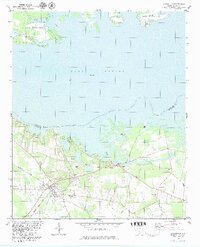
1979 Map of Eutawville
USGS Topo · Published 1979About this map
Eutawville serves as the focal point of this late-1970s study, situated just south of the expansive Lake Marion and the Santee River. The landscape reveals a transition from the structured street grid of the town to the wetlands and inlets of the Santee National Wildlife Refuge. Transportation is dominated by the Seaboard Coast Line railroad, which cuts through the southern portion of the quadrangle, passing near the Athletic Field and local industry at several Claypits.
Find a feature on this map
33 named features on this map. Tap any name to fly to it.
Don’t see what you’re looking for? This feature index may not catch every label — zoom into the map to look around manually.
Map Details
Editions of this 1979 Eutawville Map
2 editions found
Other maps of this area

1920 · Eutawville
USGS Topo · 1:48,000

1920 · Chicora
USGS Topo · 1:48,000

1920 · Manning
USGS Topo · 1:48,000

1921 · Chicora
USGS Topo · 1:62,500

1921 · Manning
USGS Topo · 1:62,500

1921 · Eutawville
USGS Topo · 1:62,500

1943 · Chicora
USGS Topo · 1:62,500

1943 · Eutawville
USGS Topo · 1:62,500

1944 · Manning
USGS Topo · 1:62,500

1954 · Augusta
USGS Topo · 1:250,000