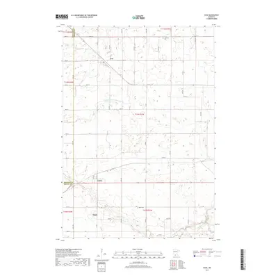
2019 Map of Evan
USGS Topo · Published 2019About this map
Evan and Cobden sit as the primary settlements in this rural landscape near the boundary of Redwood and Brown Counties. The terrain is defined by its drainage patterns, notably where the Cottonwood River cuts across the southeastern corner, joined by the winding path of Sleepy Eye Creek. A significant portion of the northern area is managed through agricultural water control, evidenced by the Redwood Brown Ditch Number One. Genealogists will find interest in localized landmarks such as Prairieville Cemetery in the northeast and Mielke Cemetery further south. The map also records the Bloemke Lakebed, illustrating how the hydrology of the region has been modified over time to support the grid of township roads and agricultural fields that dominate this portion of the Minnesota prairie.
Find a feature on this map
36 named features on this map. Tap any name to fly to it.
Don’t see what you’re looking for? This feature index may not catch every label — zoom into the map to look around manually.
Map Details
Editions of this 2019 Evan Map
This is the sole edition of this map. No revisions or reprints were ever made.
Other maps of this area

1953 · Morgan
USGS Topo · 1:62,500

1953 · New Ulm
USGS Topo · 1:250,000

1957 · New Ulm
USGS Topo · 1:250,000

1958 · New Ulm
USGS Topo · 1:250,000

1964 · Sleepy Eye NW
USGS Topo · 1:24,000

1964 · Sleepy Eye
USGS Topo · 1:24,000

1967 · New Ulm
USGS Topo · 1:250,000

1967 · Lake Hanska West
USGS Topo · 1:24,000

1967 · Springfield
USGS Topo · 1:24,000
1967 · Leavenworth
USGS Topo · 1:24,000