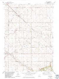
1983 Map of Evan
USGS Topo · Published 1983About this map
The Chicago and North Western railway cuts diagonally through this agricultural landscape, anchoring the rural communities of Evan and Cobden. This section of Brown County is defined by an extensive drainage system, including Judicial Ditch No 30 and County Ditch No 60, which manages the level plains of Eden and Prairieville. A unique historical marker, the Old Indian Treaty Boundary, runs across the center of the sheet, providing a geographic record of early land divisions.
Find a feature on this map
21 named features on this map. Tap any name to fly to it.
Don’t see what you’re looking for? This feature index may not catch every label — zoom into the map to look around manually.
Map Details
Editions of this 1983 Evan Map
This is the sole edition of this map. No revisions or reprints were ever made.
Other maps of this area

1953 · Morgan
USGS Topo · 1:62,500

1953 · New Ulm
USGS Topo · 1:250,000

1957 · New Ulm
USGS Topo · 1:250,000

1958 · New Ulm
USGS Topo · 1:250,000

1964 · Sleepy Eye NW
USGS Topo · 1:24,000

1964 · Sleepy Eye
USGS Topo · 1:24,000

1967 · New Ulm
USGS Topo · 1:250,000

1967 · Lake Hanska West
USGS Topo · 1:24,000

1967 · Springfield
USGS Topo · 1:24,000
1967 · Leavenworth
USGS Topo · 1:24,000