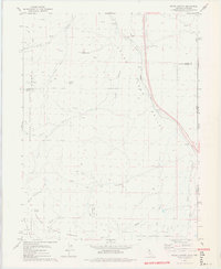
1978 Map of Evans Canyon
USGS Topo · Published 1978About this map
Balls Ranch sits in a high basin where the eastern edge of the Tahoe National Forest meets the Nevada state line. This 1978 survey highlights a landscape defined by the drainage systems of Long Valley Creek and the Western Pacific railroad line as it cuts through the canyon floor. The map documents the high-desert terrain of the Toiyabe National Forest, marked by prominent summits such as Haskell Peak and Burma Summit.
Find a feature on this map
28 named features on this map. Tap any name to fly to it.
Don’t see what you’re looking for? This feature index may not catch every label — zoom into the map to look around manually.
Map Details
Editions of this 1978 Evans Canyon Map
2 editions found
Other maps of this area

1890 · Sierraville
USGS Topo · 1:125,000

1891 · Reno
USGS Topo · 1:125,000

1892 · Sierraville
USGS Topo · 1:125,000

1893 · Reno
USGS Topo · 1:125,000

1894 · Sierraville
USGS Topo · 1:125,000

1950 · Chilcoot
USGS Topo · 1:62,500

1950 · Reno
USGS Topo · 1:62,500

1951 · Reno
USGS Topo · 1:62,500

1955 · Loyalton
USGS Topo · 1:62,500

1957 · Dogskin Mountain
USGS Topo · 1:62,500