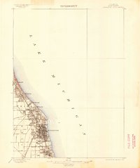
1899 Map of Evanston
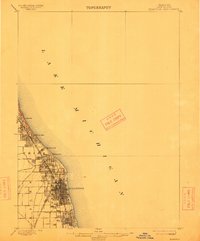
USGS Topo · Published 1905About this map
Evanston stands as the primary hub of this late 19th-century coastal survey, showing the intensive grid development along the Lake Michigan shoreline. The landscape is defined by the corridor of the Chicago and Northwestern RR, which fostered a string of residential townships including Winnetka, Kenilworth, and Wilmette. This transport artery catalyzed the transition from agricultural land to established suburbs, with the northern boundary of the Chicago City Line marking the edge of the expanding metropolis.
Find a feature on this map
13 named features on this map. Tap any name to fly to it.
Don’t see what you’re looking for? This feature index may not catch every label — zoom into the map to look around manually.
Map Details
Editions of this 1899 Evanston Map
3 editions found
Other maps of this area

1889 · Chicago
USGS Topo · 1:62,500

1891 · Chicago
USGS Topo · 1:62,500

1891 · Riverside
USGS Topo · 1:62,500

1893 · Riverside
USGS Topo · 1:62,500

1899 · Evanston
USGS Topo · 1:62,500

1900 · Chicago
USGS Topo · 1:62,500

1900 · Riverside
USGS Topo · 1:62,500

1900 · Highwood
USGS Topo · 1:62,500

1901 · Riverside
USGS Topo · 1:62,500

1901 · Chicago
USGS Topo · 1:62,500
Featured Places
- Chicago, IL
- Evanston, IL
- Skokie, Niles Township
- Wilmette, New Trier Township
- Lincolnwood, Niles Township