Loading...
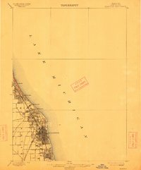
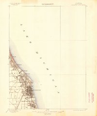
Loading map...1899 Map of Evanston
USGS Topo · Published 1912About this map
Evanston and the North Shore communities appear here as they were developing at the end of the 19th century, before the rapid suburbanization of the early 1900s. The landscape is defined by its orientation toward Lake Michigan and the critical transportation spine provided by the Chicago and Northwestern railroad. This rail corridor connects established lakefront settlements like Winnetka, Kenilworth, and Wilmette to the burgeoning urban core.
Find a feature on this map
11 named features on this map. Tap any name to fly to it.
Don’t see what you’re looking for? This feature index may not catch every label — zoom into the map to look around manually.
Map Details
Date Portrayed1899
Date Published1912
PublisherU.S. Geological Survey
Map TypeTopographic
Scale1:62,500
Physical Dimensions16.1 x 19.5 inches
Editions of this 1899 Evanston Map
3 editions found

Historical Maps of Chicago Through Time
1 maps found
Featured Locations
- Chicago, IL
- Evanston, IL
- Lincolnwood, Niles Township
- Skokie, Niles Township
- Wilmette, New Trier Township
Source Details
SourceU.S. Geological Survey
CopyrightPublic Domain