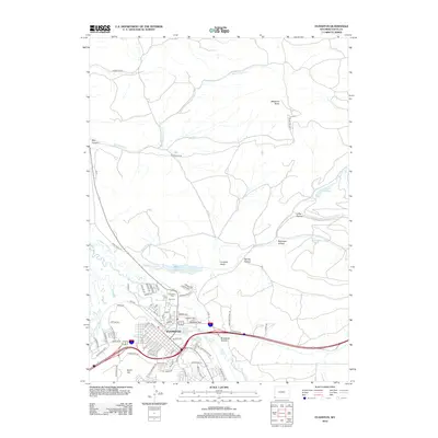
2012 Map of Evanston
USGS Topo · Published 2012About this map
The Bear River meanders through the heart of Evanston, reflecting the modern development and historical foundation of this Uinta County hub. In the early 2010s, the city's residential growth is evidenced by numerous suburban street names such as Kimberly Ave and Andrea Ave, which contrast with the core industrial presence of the Union Pacific railroad. The map provides a clear look at local landmarks and civic spaces, including Hamblin Park and Lake Louise, while also documenting burial sites important for genealogical research at the Evanston Cem and City Cem. Beyond the city limits, the landscape transitions into a series of drainages and reservoirs, such as Crompton Reservoir and Painter Reservoir. Prominent high points like Medicine Butte and Burnt Hill tower over the surrounding valleys, including the distinctive Red Canyon and Limekiln Gulch, which illustrate the varied topography of the High Plains and Rocky Mountain foothills.
Find a feature on this map
81 named features on this map. Tap any name to fly to it.
Don’t see what you’re looking for? This feature index may not catch every label — zoom into the map to look around manually.
Map Details
Editions of this 2012 Evanston Map
This is the sole edition of this map. No revisions or reprints were ever made.
Other maps of this area

1954 · Ogden
USGS Topo · 1:250,000

1958 · Ogden
USGS Topo · 1:250,000

1960 · Ogden
USGS Topo · 1:250,000

1965 · Evanston
USGS Topo · 1:24,000

1965 · Little Dee Creek
USGS Topo · 1:24,000

1965 · Sulphur Creek Reservoir
USGS Topo · 1:24,000

1965 · Guild Hollow
USGS Topo · 1:24,000

1965 · Three Forks
USGS Topo · 1:24,000

1965 · Millis
USGS Topo · 1:24,000

1968 · Wahsatch
USGS Topo · 1:24,000