1986 Map of Evansville
USGS Topo · Published 1986About this map
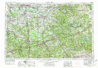
The Ohio River defines the border between Indiana and Kentucky in this mid-1980s landscape, winding past the urban centers of Evansville, Owensboro, and Henderson. Extensive river infrastructure is visible at the Newburgh Locks and Dam and Uniontown Locks and Dam, while numerous islands like Diamond Island and Racetrack Island punctuate the waterway. The region's archaeological and natural significance is noted through Angel Mounds State Memorial and the Hovey Lake Fish and Wildlife Area. Inland, the map reveals an economy driven by resource extraction, with numerous Oil Fields, Oil and Gas Fields, and a Strip Mine scattered across the terrain. Smaller settlements such as Scuffletown and Baskett sit alongside established institutions like the Indiana St Univ Evansville Campus. Physical landmarks including Graham Hill and Hickory Ridge provide relief to the river valley topography.
Find a feature on this map
230 named features on this map. Tap any name to fly to it.
Don’t see what you’re looking for? This feature index may not catch every label — zoom into the map to look around manually.
Map Details
Editions of this 1986 Evansville Map
This is the sole edition of this map. No revisions or reprints were ever made.
Historical Maps of Evansville Through Time
6 maps found