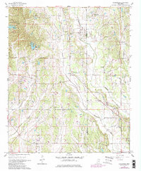
1966 Map of Evergreen
USGS Topo · Published 1979About this map
Tombigbee State Park occupies the northwestern corner of this landscape, its headquarters situated near the shores of Lake Wilhelmina. The terrain is defined by a dense network of watercourses, most notably Boguefala Creek, which winds southeast toward the Lee County and Itawamba County line. Small rural settlements like Ballardsville, Richmond, and Evergreen are connected by a web of country roads, each serving as a local hub for the surrounding farmsteads. Genealogists will find an exceptional density of family-named landmarks and historical sites, including Wesley Chapel Cem, Whiteside Cem, and Shumpert Cem. These burial grounds, alongside numerous local congregations such as Palestine Ch and Union Hill Ch, reflect the established social fabric of the mid-20th-century Mississippi hill country. Several sandpits near Pleasant Hill Ch suggest the local extraction of resources within this largely agricultural and wooded setting.
Find a feature on this map
37 named features on this map. Tap any name to fly to it.
Don’t see what you’re looking for? This feature index may not catch every label — zoom into the map to look around manually.
Map Details
Editions of this 1966 Evergreen Map
3 editions found

Other maps of this area

1921 · Tupelo
USGS Topo · 1:48,000

1923 · Tupelo
USGS Topo · 1:62,500

1956 · Tupelo
USGS Topo · 1:250,000

1958 · Tupelo
USGS Topo · 1:250,000

1965 · Mooreville
USGS Topo · 1:24,000

1965 · Fulton
USGS Topo · 1:24,000

1966 · Smithville
USGS Topo · 1:24,000

1966 · Beans Ferry
USGS Topo · 1:24,000

1966 · Shannon
USGS Topo · 1:24,000
1966 · Nettleton
USGS Topo · 1:24,000