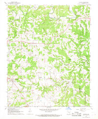
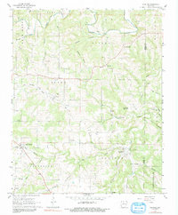
1967 Map of Everton
USGS Topo · Published 1968About this map
Everton and Valley Springs anchor this mid-century look at the Arkansas landscape where Boone and Marion counties meet. The survey reveals a region defined by its creek valleys and high ridge communities like Pleasant Ridge and Harmon. Transport history is visible in the Old Railroad Grade that winds through Olvey, marking the path of former commerce before modern highway development. Local history is deeply embedded in the land, with numerous family and community sites such as Britton Cem, Smith Cem, and Jones Cem scattered throughout the drainage areas of Crooked Creek and Clear Creek. The geography transitions from the open expanses of Prairie to the more wooded terrain near Crawford Mountain, while natural features like Settlester Cave and the Quarry near Valley Springs indicate the diverse geological and industrial character of this Ozark plateau region.
Find a feature on this map
59 named features on this map. Tap any name to fly to it.
Don’t see what you’re looking for? This feature index may not catch every label — zoom into the map to look around manually.
Map Details
Editions of this 1967 Everton Map
2 editions found
Other maps of this area

1893 · Yellville
USGS Topo · 1:125,000

1903 · Yellville
USGS Topo · 1:125,000

1904 · Harrison
USGS Topo · 1:125,000

1905 · Harrison
USGS Topo · 1:125,000

1905 · Yellville
USGS Topo · 1:125,000

1929 · Yellville
USGS Topo · 1:125,000

1945 · Harrison
USGS Topo · 1:250,000

1949 · Harrison
USGS Topo · 1:250,000

1954 · Harrison
USGS Topo · 1:250,000

1958 · Harrison
USGS Topo · 1:250,000