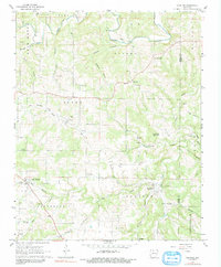
1967 Map of Everton
USGS Topo · Published 1991About this map
Crooked Creek meanders through the northern hills of Boone County, anchoring a landscape defined by small rural communities and family legacies. Near the settlement of Everton, the terrain is marked by the path of an Old Railroad Grade, reflecting the importance of historical transit corridors through the Ozark foothills. Genealogists will find a high density of family burial grounds, including the Britton, Warner, and Newton cemeteries, which are scattered among the ridges and hollows near Rally Hill and Olvey.
Find a feature on this map
52 named features on this map. Tap any name to fly to it.
Don’t see what you’re looking for? This feature index may not catch every label — zoom into the map to look around manually.
Map Details
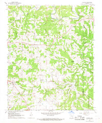
Editions of this 1967 Everton Map
2 editions found
Other maps of this area

1893 · Yellville
USGS Topo · 1:125,000

1903 · Yellville
USGS Topo · 1:125,000

1904 · Harrison
USGS Topo · 1:125,000

1905 · Harrison
USGS Topo · 1:125,000

1905 · Yellville
USGS Topo · 1:125,000

1929 · Yellville
USGS Topo · 1:125,000

1945 · Harrison
USGS Topo · 1:250,000

1949 · Harrison
USGS Topo · 1:250,000

1954 · Harrison
USGS Topo · 1:250,000

1958 · Harrison
USGS Topo · 1:250,000