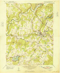
1948 Map of Factoryville
USGS Topo · Published 1948About this map
Keystone College serves as a cultural anchor in this post-war landscape, situated where the South Branch Tunkhannock Creek meets the village of Factoryville. The terrain is defined by its transition from the steep ridges of Middle Mountain and Bunker Hill to the recreational waters of Lake Winola and Lake Sheridan. Local transport is dominated by the Delaware Lackawanna and Western RR, which cuts through the ridge via a notable Tunnel near Tunnel Hill Sch.
Find a feature on this map
62 named features on this map. Tap any name to fly to it.
Don’t see what you’re looking for? This feature index may not catch every label — zoom into the map to look around manually.
Map Details
Editions of this 1948 Factoryville Map
2 editions found
Other maps of this area

1889 · Scranton
USGS Topo · 1:62,500

1891 · Scranton
USGS Topo · 1:62,500

1892 · Dundaff
USGS Topo · 1:62,500

1893 · Pittston
USGS Topo · 1:62,500

1893 · Scranton
USGS Topo · 1:62,500

1943 · Scranton
USGS Topo · 1:125,000

1946 · Tunkhannock
USGS Topo · 1:62,500

1946 · Dalton
USGS Topo · 1:24,000

1946 · Ransom
USGS Topo · 1:24,000

1946 · Factoryville
USGS Topo · 1:24,000