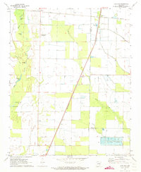
1971 Map of Fair Oaks
USGS Topo · Published 1973About this map
The St Louis Southwestern and Missouri Pacific railroads intersect at Fair Oaks, anchoring this agricultural landscape where Woodruff, Cross, and St. Francis counties meet. The eastern portion of the survey is defined by an organized grid of irrigation and drainage, including distinctive Minnow Ponds and fish farms that speak to the region's specialized aquaculture in the early 1970s.
Find a feature on this map
23 named features on this map. Tap any name to fly to it.
Don’t see what you’re looking for? This feature index may not catch every label — zoom into the map to look around manually.
Map Details
Editions of this 1971 Fair Oaks Map
This is the sole edition of this map. No revisions or reprints were ever made.
Other maps of this area

1939 · Vanndale
USGS Topo · 1:62,500

1939 · Wynne
USGS Topo · 1:62,500

1939 · Hunter
USGS Topo · 1:62,500

1940 · Tilton
USGS Topo · 1:62,500

1953 · Memphis
USGS Topo · 1:250,000

1956 · Memphis
USGS Topo · 1:250,000

1956 · Tilton
USGS Topo · 1:62,500

1956 · Hunter
USGS Topo · 1:62,500

1958 · Hunter
USGS Topo · 1:62,500

1958 · Wynne
USGS Topo · 1:62,500