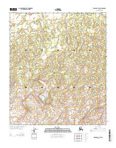
2013 Map of Fairbanks C-6 SW
USGS Topo · Published 2013About this map
Ddhel Th'oyh Mena' serves as the central named feature of this interior Alaska landscape, situated within the vast Yukon-Koyukuk region. This 2013 survey by the U.S. Geological Survey maps a section of the wilderness defined by its complex hydrography and public land survey grid, including the intersection of several townships. The map documents the intricate network of small lakes and drainage patterns characteristic of the northern terrain before more modern human developments altered the natural state. While largely devoid of named settlements, the topography provides a precise record of the elevation and water distribution that dictates travel and subsistence patterns in this part of the Fairbanks C-6 SW quadrangle.
Find a feature on this map
4 named features on this map. Tap any name to fly to it.
Don’t see what you’re looking for? This feature index may not catch every label — zoom into the map to look around manually.
Map Details
Editions of this 2013 Fairbanks C-6 SW Map
This is the sole edition of this map. No revisions or reprints were ever made.
Other maps of this area

1948 · Kantishna River
USGS Topo · 1:250,000

1950 · Fairbanks
USGS Topo · 1:250,000

1951 · Kantishna River
USGS Topo · 1:250,000

1951 · Fairbanks
USGS Topo · 1:250,000

1952 · Kantishna River C-1
USGS Topo · 1:63,360

1952 · Kantishna River
USGS Topo · 1:250,000

1952 · Kantishna River B-1
USGS Topo · 1:63,360

1952 · Fairbanks
USGS Topo · 1:250,000
1953 · Fairbanks C-6
USGS Topo · 1:63,360
1953 · Fairbanks B-6
USGS Topo · 1:63,360