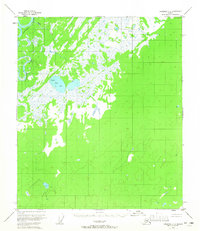
1953 Map of Fairbanks C-6
USGS Topo · Published 1965About this map
Kantishna River meanders through the northwest corner of this interior Alaskan landscape, a region defined by extensive wetlands and complex water systems. Surveyed via photogrammetric methods in the early 1950s, the terrain is dominated by a vast expanse of swamp and muskeg, punctuated by bodies of water like Black Bear Lake and the winding course of Rock Creek. These maps were produced before the era of widespread development, showing unsurveyed and unmarked land lines as predetermined by the Bureau of Land Management. The lack of established roads or trails reflects the isolation of the area during the mid-century period, where movement was primarily dictated by river systems and the seasonal nature of the marshy ground.
Find a feature on this map
3 named features on this map. Tap any name to fly to it.
Don’t see what you’re looking for? This feature index may not catch every label — zoom into the map to look around manually.
Map Details
Editions of this 1953 Fairbanks C-6 Map
3 editions found
Other maps of this area

1948 · Kantishna River
USGS Topo · 1:250,000

1949 · Fairbanks B-5
USGS Topo · 1:63,360

1950 · Fairbanks
USGS Topo · 1:250,000

1950 · Fairbanks C-5
USGS Topo · 1:63,360

1950 · Fairbanks D-5
USGS Topo · 1:63,360

1950 · Fairbanks B-5
USGS Topo · 1:63,360

1951 · Kantishna River
USGS Topo · 1:250,000

1951 · Fairbanks B-5
USGS Topo · 1:63,360

1951 · Fairbanks
USGS Topo · 1:250,000
1952 · Fairbanks C-5
USGS Topo · 1:63,360