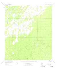
1953 Map of Fairbanks C-6
USGS Topo · Published 1975About this map
Kantishna River meanders through this interior Alaska landscape, defining the western edge of a region characterized by extensive wetlands and glacial drainage patterns. Surveyed in the early 1950s, the terrain shows a vast network of unnamed ponds and marshes typical of the low-lying Tanana Valley periphery. Black Bear Lake sits as a prominent landmark amidst the muskeg, while Rock Creek drains the northern reaches. The lack of roads or established settlements on this sheet reflects the isolation of the Yukon-Koyukuk region during this era, where travel was primarily dictated by the seasonal flow of major waterways and the frozen winter tundra.
Find a feature on this map
3 named features on this map. Tap any name to fly to it.
Don’t see what you’re looking for? This feature index may not catch every label — zoom into the map to look around manually.
Map Details
Editions of this 1953 Fairbanks C-6 Map
3 editions found
Other maps of this area

1948 · Kantishna River
USGS Topo · 1:250,000

1949 · Fairbanks B-5
USGS Topo · 1:63,360

1950 · Fairbanks
USGS Topo · 1:250,000

1950 · Fairbanks C-5
USGS Topo · 1:63,360

1950 · Fairbanks D-5
USGS Topo · 1:63,360

1950 · Fairbanks B-5
USGS Topo · 1:63,360

1951 · Kantishna River
USGS Topo · 1:250,000

1951 · Fairbanks B-5
USGS Topo · 1:63,360

1951 · Fairbanks
USGS Topo · 1:250,000
1952 · Fairbanks C-5
USGS Topo · 1:63,360