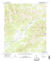
1950 Map of Fairbanks D-3
USGS Topo · Published 1974About this map
Alaska Railroad tracks wind through the heart of this interior Alaskan landscape, connecting the small settlements of Saulich and Old Saulich as the line parallels the meandering course of Goldstream Creek. The map documents a rugged subarctic environment defined by complex hydrology and high-altitude landmarks, including the prominent Ester Dome Observatory and Murphy Dome, which hosts a Military Reservation and its associated landing strip. To the south, the Bonanza Creek Experimental Forest borders the wide reaches of the Tanana River. Near the Ester settlement, specialized infrastructure like a ski lodge and the Ready Bullion Creek Trail indicate the transition of the area from purely industrial or military use toward recreational and residential life as Fairbanks expanded in the mid-20th century.
Find a feature on this map
55 named features on this map. Tap any name to fly to it.
Don’t see what you’re looking for? This feature index may not catch every label — zoom into the map to look around manually.
Map Details
Editions of this 1950 Fairbanks D-3 Map
4 editions found
Other maps of this area

1945 · Livengood
USGS Topo · 1:250,000

1949 · Fairbanks D-2
USGS Topo · 1:62,500

1949 · Fairbanks D-3
USGS Topo · 1:63,360

1949 · Fairbanks D-4
USGS Topo · 1:63,360

1949 · Fairbanks C-2
USGS Topo · 1:63,360

1950 · Fairbanks
USGS Topo · 1:250,000

1950 · Fairbanks C-3
USGS Topo · 1:63,360

1950 · Fairbanks C-4
USGS Topo · 1:63,360

1950 · Fairbanks D-3
USGS Topo · 1:63,360

1951 · Fairbanks
USGS Topo · 1:250,000