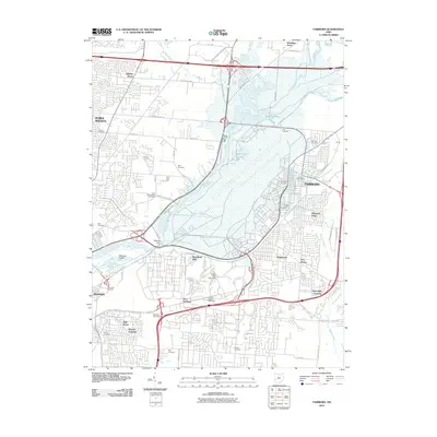
2010 Map of Fairborn
USGS Topo · Published 2010About this map
Fairborn and the expansive campus of Wright State University dominate this 2010 survey of the northeastern Dayton suburbs. The landscape is defined by the convergence of major infrastructure and significant water features, including the Huffman Dam on the Mad River. The map meticulously documents the dense suburban development of Huber Heights and Riverside, contrasting with the open water of Medway Lake and Bass Lake.
Find a feature on this map
66 named features on this map. Tap any name to fly to it.
Don’t see what you’re looking for? This feature index may not catch every label — zoom into the map to look around manually.
Map Details
Editions of this 2010 Fairborn Map
This is the sole edition of this map. No revisions or reprints were ever made.
Other maps of this area

1904 · Springfield
USGS Topo · 1:62,500

1904 · Dayton
USGS Topo · 1:62,500

1906 · Dayton
USGS Topo · 1:62,500

1906 · Springfield
USGS Topo · 1:62,500

1913 · Waynesville
USGS Topo · 1:62,500

1915 · Waynesville
USGS Topo · 1:62,500

1917 · Xenia
USGS Topo · 1:62,500

1947 · Columbus
USGS Topo · 1:250,000

1953 · Cincinnati
USGS Topo · 1:250,000
1955 · Donnelsville
USGS Topo · 1:24,000