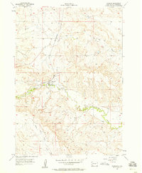
1957 Map of Fairburn
USGS Topo · Published 1958About this map
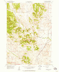
Fairburn sits as the central settlement in this 1957 survey, positioned where the Chicago and North Western railroad meets the meandering path of French Creek. The landscape is defined by the drainage patterns of these watercourses, including the seasonal Dry Creek to the north and the South Fork French Creek in the southwest. For genealogists, the Fairburn Cem is clearly marked just east of the main townsite. The involvement of the United States Atomic Energy Commission in the margin hints at the strategic importance of the Black Hills region during this period of the Cold War, even as the map documents a quiet rural landscape of section lines and stream beds.
Find a feature on this map
6 named features on this map. Tap any name to fly to it.
Don’t see what you’re looking for? This feature index may not catch every label — zoom into the map to look around manually.
Map Details
Editions of this 1957 Fairburn Map
Other maps of this area

1894 · Hermosa
USGS Topo · 1:125,000

1901 · Hermosa
USGS Topo · 1:125,000

1951 · Fairburn SE
USGS Topo · 1:24,000

1953 · Hermosa
USGS Topo · 1:24,000

1953 · Hermosa SE
USGS Topo · 1:24,000

1954 · Hayward
USGS Topo · 1:24,000

1954 · Mount Rushmore
USGS Topo · 1:62,500

1955 · Hot Springs
USGS Topo · 1:250,000
1957 · Fairburn NE
USGS Topo · 1:24,000
1957 · Butcher Hill
USGS Topo · 1:24,000