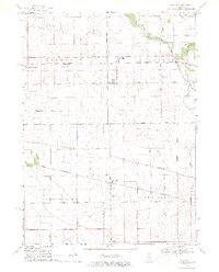
1968 Map of Fairdale
USGS Topo · Published 1970About this map
The South Branch Kishwaukee River winds through the northern corner of this mid-1960s landscape, serving as a focal point for the small community of Fairdale and the nearby Camp Rotary McQueen. This territory at the boundary of Ogle Co De Kalb Co is defined by a dense grid of rural roads and competing rail lines. The Chicago Milwaukee St Paul and Pacific runs through the northern half, passing Monroe Center, while the Chicago and North Western cuts across the south through Esmond. Genealogists will find several rural burial grounds preserved in this agricultural landscape, including Roseland Cem, Porter Cem, and Greenview Cem. Numerous gravel pits and quarries dot the terrain, particularly near the river and along Irene Road, highlighting the local extraction industry of the era.
Find a feature on this map
34 named features on this map. Tap any name to fly to it.
Don’t see what you’re looking for? This feature index may not catch every label — zoom into the map to look around manually.
Map Details
Editions of this 1968 Fairdale Map
2 editions found
Other maps of this area

1917 · Kings
USGS Topo · 1:62,500

1918 · Kings
USGS Topo · 1:62,500

1918 · Kirkland
USGS Topo · 1:62,500

1934 · De Kalb
USGS Topo · 1:62,500

1937 · De Kalb
USGS Topo · 1:62,500

1949 · Camp Grant
USGS Topo · 1:24,000

1952 · Rochelle
USGS Topo · 1:62,500

1954 · Rockford
USGS Topo · 1:250,000

1955 · Rockford
USGS Topo · 1:250,000

1958 · Aurora
USGS Topo · 1:250,000