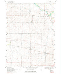
1968 Map of Fairdale
USGS Topo · Published 1984About this map
Fairdale and Monroe Center serve as the primary hubs in this agricultural landscape straddling the border of Ogle and De Kalb Counties. The area is defined by a sophisticated transportation network of the late 1960s, where the Chicago Milwaukee St Paul and Pacific and the Chicago and North Western rail lines bisect the prairie. These rail corridors, alongside an Old RR Grade, illustrate the shifting priorities of mid-century transit and cargo moving through Lynnville and South Grove.
Find a feature on this map
34 named features on this map. Tap any name to fly to it.
Don’t see what you’re looking for? This feature index may not catch every label — zoom into the map to look around manually.
Map Details
Editions of this 1968 Fairdale Map
2 editions found
Other maps of this area

1917 · Kings
USGS Topo · 1:62,500

1918 · Kings
USGS Topo · 1:62,500

1918 · Kirkland
USGS Topo · 1:62,500

1934 · De Kalb
USGS Topo · 1:62,500

1937 · De Kalb
USGS Topo · 1:62,500

1949 · Camp Grant
USGS Topo · 1:24,000

1952 · Rochelle
USGS Topo · 1:62,500

1954 · Rockford
USGS Topo · 1:250,000

1955 · Rockford
USGS Topo · 1:250,000

1958 · Aurora
USGS Topo · 1:250,000