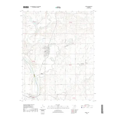
2018 Map of Fairfax
USGS Topo · Published 2018About this map
Fairfax serves as the central hub of this northern Oklahoma landscape, where the prairie transitions into the drainage basins of the Arkansas River and Salt Creek. The town is flanked by historic sites like the Fairfax Cem and Haskell Cem, which speak to the area's early settlement. To the east, the community of Gray Horse sits near its namesake Gray Horse Cr and Gray Horse Cem, highlighting the deep indigenous roots of Osage County. The terrain is marked by distinct features such as Round Mound and the winding Threemile Canyon. In the southern portion of the sheet, Osage Junction and the town of Ralston mark the border between Osage and Pawnee counties, situated where the terrain meets the river's southern banks. The presence of Fairfax City Lake and numerous creeks like Solomon Cr and Tate Cr define the hydrological character of this ranching and prairie region.
Find a feature on this map
66 named features on this map. Tap any name to fly to it.
Don’t see what you’re looking for? This feature index may not catch every label — zoom into the map to look around manually.
Map Details
Editions of this 2018 Fairfax Map
This is the sole edition of this map. No revisions or reprints were ever made.
Other maps of this area

1929 · Skedee
USGS Topo · 1:62,500

1930 · Pawnee
USGS Topo · 1:62,500

1931 · Skedee
USGS Topo · 1:62,500

1932 · Fairfax
USGS Topo · 1:62,500

1936 · Belford
USGS Topo · 1:62,500

1936 · Pawnee
USGS Topo · 1:62,500

1955 · Enid
USGS Topo · 1:250,000

1958 · Enid
USGS Topo · 1:250,000

1964 · Charley Creek NE
USGS Topo · 1:24,000
1978 · Burbank
USGS Topo · 1:24,000