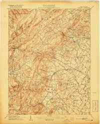
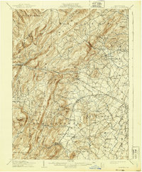
1909 Map of Fairfield
USGS Topo · Published 1918About this map
Fairfield and its neighboring Adams County townships are defined by the convergence of early industrial sites and agricultural valleys along the Western Maryland RR. The presence of Maria Furnace and Iron Springs at the base of Jacks Mountain points to the region's early iron heritage, while numerous schools like Clearspring School and Brady School dot the landscape. To the east, the map captures the western fringe of the Gettysburg Confederate Avenue, showing the landscape just decades after the Civil War. Transportation routes such as the Chambersburg Pike connect established settlements like Cashtown and McKnightstown, which served as vital hubs for the local rural economy during this period of early twentieth-century growth.
Find a feature on this map
129 named features on this map. Tap any name to fly to it.
Don’t see what you’re looking for? This feature index may not catch every label — zoom into the map to look around manually.
Map Details
Editions of this 1909 Fairfield Map
6 editions found
Other maps of this area

1902 · Chambersburg
USGS Topo · 1:62,500

1904 · Carlisle
USGS Topo · 1:62,500

1908 · Gettysburg
USGS Topo · 1:62,500

1909 · Fairfield
USGS Topo · 1:62,500

1909 · Hagerstown
USGS Topo · 1:48,000

1911 · Taneytown
USGS Topo · 1:62,500

1911 · Emmitsburg
USGS Topo · 1:62,500

1912 · Hagerstown
USGS Topo · 1:62,500

1919 · Newville
USGS Topo · 1:62,500

1923 · Shippensburg
USGS Topo · 1:62,500