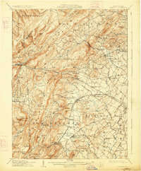
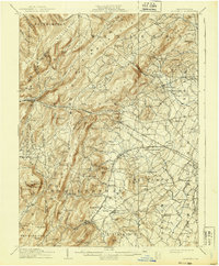
1909 Map of Fairfield
USGS Topo · Published 1927About this map
South Mountain dominates the western landscape of this early twentieth-century survey, where the rugged topography of the Big Flat meets the agricultural valleys of western Adams County. The settlement patterns follow the established turnpikes and the developing rail infrastructure of the Western Maryland RR, which winds through the mountain gaps at Iron Springs. Local industrial history is marked by the presence of Maria Furnace, while the social geography of the era is evidenced by the prominent South Mountain Sanatorium and a dense network of rural schoolhouses such as Liberty Hall School and McCleary School. Significant transit corridors like the Chambersburg Pike and the Harrisburg and Division Line connect historic crossroads including Cashtown, McKnightstown, and Seven Stars, illustrating the transition from 19th-century furnace and mill economies to 20th-century rail-dependent villages.
Find a feature on this map
114 named features on this map. Tap any name to fly to it.
Don’t see what you’re looking for? This feature index may not catch every label — zoom into the map to look around manually.
Map Details
Editions of this 1909 Fairfield Map
6 editions found
Other maps of this area

1902 · Chambersburg
USGS Topo · 1:62,500

1904 · Carlisle
USGS Topo · 1:62,500

1908 · Gettysburg
USGS Topo · 1:62,500

1909 · Fairfield
USGS Topo · 1:62,500

1909 · Hagerstown
USGS Topo · 1:48,000

1911 · Taneytown
USGS Topo · 1:62,500

1911 · Emmitsburg
USGS Topo · 1:62,500

1912 · Hagerstown
USGS Topo · 1:62,500

1919 · Newville
USGS Topo · 1:62,500

1923 · Shippensburg
USGS Topo · 1:62,500