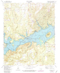
1973 Map of Fairfield Bay
USGS Topo · Published 1982About this map
Greers Ferry Lake dominates this mid-1970s view of the border between Van Buren and Cleburne counties, its irregular shoreline reaching deep into the Ozark foothills at an elevation of 461 feet. The map reveals the early development of Fairfield Bay, complete with its planned Golf Course and utility infrastructure like the Sewage Disposal and a Substation. This period of growth is set against the older rural landscape of Eglantine, where the Eglantine Cemetery and United Methodist Church anchor the local community history.
Find a feature on this map
46 named features on this map. Tap any name to fly to it.
Don’t see what you’re looking for? This feature index may not catch every label — zoom into the map to look around manually.
Map Details
Editions of this 1973 Fairfield Bay Map
3 editions found
Other maps of this area

1892 · Mountain View
USGS Topo · 1:125,000

1894 · Mountain View
USGS Topo · 1:125,000

1956 · Russellville
USGS Topo · 1:250,000

1961 · Bee Branch
USGS Topo · 1:62,500

1961 · Bee Branch
USGS Topo · 1:24,000

1961 · Morganton
USGS Topo · 1:24,000

1963 · Quitman
USGS Topo · 1:24,000

1964 · Russellville
USGS Topo · 1:250,000
1973 · Fairfield Bay
USGS Topo · 1:24,000
1973 · Greers Ferry
USGS Topo · 1:24,000