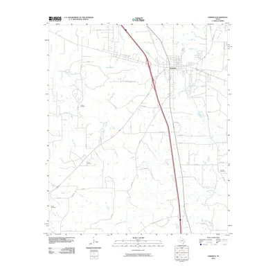
2010 Map of Fairfield
USGS Topo · Published 2010About this map
Fairfield serves as the central hub of this East Texas landscape, where the convergence of major thoroughfares like FM 27 and the Old Mexia-Fairfield Rd meet modern highway infrastructure. The surrounding countryside is defined by an intricate drainage system including Upper Keechi Creek, Mims Creek, and Walthall Creek, which carve through the terrain south of the town center. For those researching local heritage, several significant family and community burial sites are documented across the rural acreage, including George Cemetery to the west, Driver Cemetery to the southwest, and Post Oak Cemetery near the eastern boundary. The presence of Jones Lake Dam and Sneed Lake indicates the managed water resources essential to the region's agricultural and residential development during this era of the early 21st century.
Find a feature on this map
54 named features on this map. Tap any name to fly to it.
Don’t see what you’re looking for? This feature index may not catch every label — zoom into the map to look around manually.
Map Details
Editions of this 2010 Fairfield Map
This is the sole edition of this map. No revisions or reprints were ever made.
Other maps of this area

1919 · Fairfield
USGS Topo · 1:62,500

1920 · Mexia
USGS Topo · 1:62,500

1954 · Waco
USGS Topo · 1:250,000

1955 · Waco
USGS Topo · 1:250,000

1961 · Young
USGS Topo · 1:24,000

1963 · Teague North
USGS Topo · 1:24,000

1963 · Kirvin
USGS Topo · 1:24,000
1963 · Stewards Mill
USGS Topo · 1:24,000

1965 · Dew
USGS Topo · 1:24,000
1965 · Lanely
USGS Topo · 1:24,000