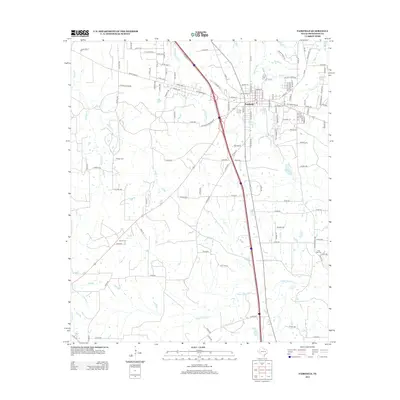
2013 Map of Fairfield
USGS Topo · Published 2013About this map
Fairfield serves as the central hub of this East Texas landscape, where the convergence of Interstate 45 and local routes shapes the modern development of Freestone County. The map details a transition from the structured street grid of the town center to the sprawling ranch and agricultural lands defined by an extensive network of county roads, such as Co Rd 940 and Co Rd 601. For genealogical research, several family-named landmarks and burial sites are documented, including George Cem, Driver Cem, and Post Oak Cem. The terrain is drained by numerous winding waterways, notably Upper Keechi Cr, Mims Cr, and Cottonwood Cr, which meander through the prairie. Smaller features like Sneed Lake and Tanbark Br provide specific points of reference for those tracing local property lines or family history in this cattle and timber region.
Find a feature on this map
127 named features on this map. Tap any name to fly to it.
Don’t see what you’re looking for? This feature index may not catch every label — zoom into the map to look around manually.
Map Details
Editions of this 2013 Fairfield Map
This is the sole edition of this map. No revisions or reprints were ever made.
Other maps of this area

1919 · Fairfield
USGS Topo · 1:62,500

1920 · Mexia
USGS Topo · 1:62,500

1954 · Waco
USGS Topo · 1:250,000

1955 · Waco
USGS Topo · 1:250,000

1961 · Young
USGS Topo · 1:24,000

1963 · Teague North
USGS Topo · 1:24,000

1963 · Kirvin
USGS Topo · 1:24,000
1963 · Stewards Mill
USGS Topo · 1:24,000

1965 · Dew
USGS Topo · 1:24,000
1965 · Lanely
USGS Topo · 1:24,000