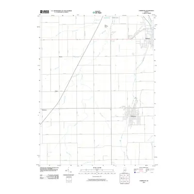
2010 Map of Fairmount
USGS Topo · Published 2010About this map
The Mississinewa River cuts through the northeast corner of this Grant County landscape, framing the developed streets of Jonesboro. This 2010 survey illustrates a quintessential Midwestern agricultural and residential grid, defined by a network of drainage infrastructure like Dry Fork Ditch, Little Newby Ditch, and Stuckey Ditch that manage the local hydrology. To the south, the town of Fairmount serves as a primary hub, its street plan extending toward the expansive Park Cemetery.
Find a feature on this map
45 named features on this map. Tap any name to fly to it.
Don’t see what you’re looking for? This feature index may not catch every label — zoom into the map to look around manually.
Map Details
Editions of this 2010 Fairmount Map
This is the sole edition of this map. No revisions or reprints were ever made.
Other maps of this area

1953 · Muncie
USGS Topo · 1:250,000

1956 · Muncie
USGS Topo · 1:250,000

1960 · Elwood
USGS Topo · 1:24,000

1960 · Point Isabel
USGS Topo · 1:24,000

1960 · Alexandria
USGS Topo · 1:24,000

1960 · Fairmount
USGS Topo · 1:24,000

1960 · Gas City
USGS Topo · 1:24,000

1960 · Gaston
USGS Topo · 1:24,000

1961 · Marion
USGS Topo · 1:24,000
1962 · Sweetser
USGS Topo · 1:24,000