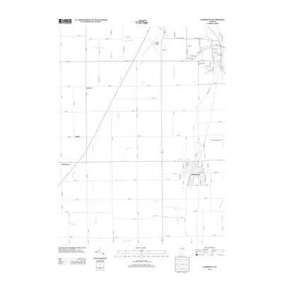
2013 Map of Fairmount
USGS Topo · Published 2013About this map
Fairmount serves as the primary hub of this East Central Indiana landscape, exhibiting a dense residential grid situated amidst a complex network of agricultural drainage. The area's aviation infrastructure is represented by the Marion Municipal Airport in the north and the smaller Peacock Farms Airport to the east. Small unincorporated communities like Weaver, Radley, and Hackleman are scattered across the terrain, connected by an exacting grid of county roads such as W 600 S and Co RD-100. This 2013 survey illustrates the extensive human modification of the local hydrology required for farming, featuring named water management systems like Stuckey Ditch, Jones Clark Ditch, and Winslow Ditch. The natural flow of Deer Cr and Little Deer Cr winds through these fields, while Glendale Lake provides a rare open water body in a region otherwise defined by straight-line ditches and tributary creeks like Back Cr and Little Cr.
Find a feature on this map
117 named features on this map. Tap any name to fly to it.
Don’t see what you’re looking for? This feature index may not catch every label — zoom into the map to look around manually.
Map Details
Editions of this 2013 Fairmount Map
This is the sole edition of this map. No revisions or reprints were ever made.
Other maps of this area

1953 · Muncie
USGS Topo · 1:250,000

1956 · Muncie
USGS Topo · 1:250,000

1960 · Elwood
USGS Topo · 1:24,000

1960 · Point Isabel
USGS Topo · 1:24,000

1960 · Alexandria
USGS Topo · 1:24,000

1960 · Fairmount
USGS Topo · 1:24,000

1960 · Gas City
USGS Topo · 1:24,000

1960 · Gaston
USGS Topo · 1:24,000

1961 · Marion
USGS Topo · 1:24,000
1962 · Sweetser
USGS Topo · 1:24,000